Sequoia National Park: Mineral King Loop
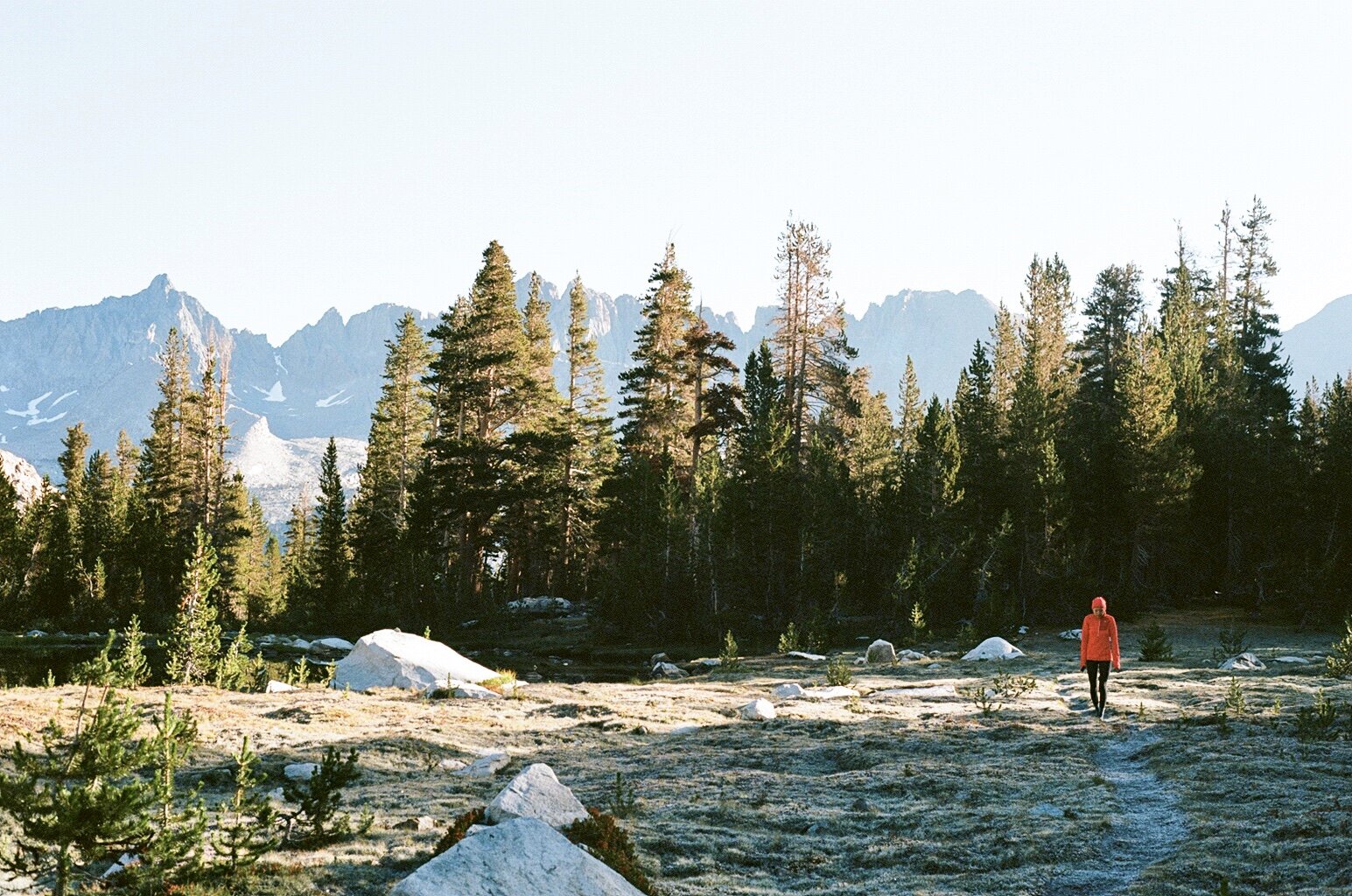
View of peaks from Big Five Lakes Trail
Location: Sequoia National Park, CA
Duration: 4 days, 3 nights
Dates Hiked: September 11-14, 2019
Mileage: 30 miles
Elevation: ~9,100 ft elevation gain
Temperature: Around the 50-60s (F) in the daytime, 30s (F) at night
Camps: Pinto Lake, Little Five Lakes, Lost Canyon
Permit: Yes
Trailhead: Sawtooth (loop)
Destinations: Pinto Lake, Black Rock Pass, Little Five Lakes, Big Five Lakes, Lost Canyon, Columbine Lake, Sawtooth Pass, Monarch Lakes
Traverse through varied terrain, from glacial cirques, lush meadows, and towering groves of giant conifers, to granite peaks and alpine lakes. The Mineral King Loop is breathtaking in views and physicality. Located in the southern part of Sequoia National Park, this route, at the time, was the most arduous trek I’ve done in my backpacking career (no longer the Thousand Island Lake Loop).
This backpacking trip almost never happened. Earlier in the spring, Reko and I both applied for permits for the Wonderland Trail in Mt. Rainier National Park via the online lottery. I miraculously scored a permit! Securing permits for the Wonderland Trail is incredibly difficult, especially via the lottery system. It’s basically the equivalent of gaining acceptance to the Harvard University of the backpacking world. We were excited and also intimidated.
At the same time that I submitted an application for the Wonderland Trail, I also applied for a permit for the Mineral King Loop in Sequoia National Park. I put down the same dates for both applications (mid-September)—of course Mineral King being a much shorter loop. We had better odds of scoring a permit for Mineral King than the Wonderland Trail since MK was first come, first served. Plus, the Mineral King Loop is pretty obscure, which makes sense. Accessing Mineral King is a whole journey in itself.
Thus, I had zero expectations of getting a permit for the WT. It was a long shot so I happily accepted the fate that we would have the opportunity to explore another national park (we had previously visited Mt. Rainier NP in August 2017). As I predicted, we were awarded our permit for Mineral King in April. A few days later, I received an email from the NPS. Our trip itinerary for the WT was approved and we were given a permit!!! HOLY GUAC! How did we get so lucky? We never win anything!
Throughout the summer, Reko and I trained for the WT. We tackled rigorous hikes with steep slopes and long miles. A combination of us going too hard too fast, and our old age (lol, semi kidding) resulted in an unfortunate slew of hiking injuries. As we approached September, we ultimately decided our bodies and minds were not prepared for a nine-day backcountry trek. We forfeit our Wonderland Trail dreams and permit. However, we still wanted one more notch on our belts before the season ended. (We had only backpacked once that summer to Thousand Island Lake.) So, Mineral King, here we come!
LOGISTICS
The permit application for Mineral King is confusing if you’re not attentive. First, determine which direction you want to hike the loop. The hike starts at Sawtooth Trailhead and Sawtooth Pass Trail, which eventually splits off to the Timber Gap Trail at 0.6 miles. If you’re hiking the loop in a clockwise direction (which is what we did and highly recommended), then you’d take the Timber Gap Trail. If you want to hike in the counter-clockwise direction, you’d continue on the Sawtooth Pass Trail. Either way, you’re starting from Sawtooth TH but the direction of the loop determines the “entry” trailhead on the application: either Timber Gap or Sawtooth Pass.
Once you have the direction, check if there are reservations available for the entry trailhead for your desired start date. If your dates check out, then it’s a three-step process to apply for a permit:
Apply online at least two weeks prior to your start date.
Pay for the permit - If you successfully secure a reservation, the NPS will email you a confirmation letter with a link to their pay.gov payment form. Wilderness permits cost $10, plus $5 per person within the quota season (normally late May through late September).
Pick up your permit from the Mineral King Ranger Station, either on the day before or the day of your hike. A permit reservation is not your actual permit!
Also, please educate yourself on the marmot situation so you arrive well prepared. This is no joke! Since we went in September, marmots weren’t an issue and we didn’t have to marmot-proof our truck.
Getting to Mineral King is an adventure. From the turnoff in Three Rivers, it’s a long and treacherous 25 miles to Mineral King. Prepare for 1.5 hours of tight turns on a single windy dirt road that climbs over 6,400 feet. This also explains why this area is low trafficked.
Below is our trip itinerary with mileage. Milage will vary depending on how far/deep you go to find a campsite.
Day 1 - 8 miles
Take Timber Gap Trail from Sawtooth Trailhead, continue on Black Rock Pass Trail after Cliff Creek, camp at Pinto LakeDay 2 - 5 miles
From Pinto Lake, climb to the top of Black Rock Pass, head down on Big Five Lakes Trail to Little Five and Big Five Lakes to camp (we camped at Little Five)Day 3 - 7 miles
Continue on Big Five Lakes Trail until reaching Lost Canyon Trail, camp at Lost CanyonDay 4 - 10 miles
Continue on Lost Canyon Trail, climb to Columbine Lake and Sawtooth Pass, descend down to Monarch Lakes and continue on Sawtooth Pass Trail until returning to Sawtooth TH
Here is a map of the loop. I advise hiking this loop in 4-5 days, and (again) going clockwise. The elevation gain is the same in either direction but it would be a nightmare climbing up Sawtooth Pass on the first day with a full pack because it’s literally all loose gravel. It’s much safer and more pleasant to scree down the pass on your last day with a light load. (Gaiters and trekking poles are strongly advised.)
Silver City Resort is the only form of civilization in Mineral King, and we lodged here for a night. This resort is made up of cabins, a shop, and a restaurant. It is pricey since it’s hard to maintain or provide any sort of accommodations in such a remote area.
LEAVE NO TRACE
Please please PLEASE practice Leave No Trace principles. Pack out everything, including toilet paper. For #2, dig a cathole 6-8 inches deep, and at least 200 ft from water, camp, and trails. Don’t be a jerk to Mother Nature. Let’s protect our precious natural world.
Enjoying a cold one during our last night in civilization at Silver City Restaurant.
TRIP REPORT
On Tuesday morning of September 10th, Reko and I set out from the bay and embarked on our second and last backpacking trip of the year. For someone who suffers from carsickness on twisty roads, I emerged from the drive into Mineral King unscathed. We arrived at the Mineral King Ranger Station right before they closed and picked up our permit. When I stepped out of the car, I froze. Literally. It was so chilly. The cold, sharp air jolted my senses. During this trek, daytime temperatures dipped into the 50s. At night, it was freezing.
As I mentioned earlier—and true to my OCDness—we stayed at Silver City Resort the day before our trip so we could enjoy one last night of creature comforts before roughing it out. We also wanted a night to acclimatize because we would be hiking in elevations of 8-11K feet.
We stayed in the Evelyn Lake Studio, which had more than ample space for two travelers. After unpacking and dealing with a slight issue with the in-room heater that required staff assistance, we treated our clothes with bug spray. (Bugs ended up not being an issue at all.) Then, we headed to the small restaurant and enjoyed some beers. I remember how cold it was walking back to our room from the restaurant. I was nervous but also excited for the adventure awaiting us.
The next morning we inhaled our BBQ pork buns that we had purchased the day before at 99 Ranch on our way out of the Bay Area. We grabbed our packs and drove down to Sawtooth Trailhead, a short 10-minute ride from the resort. The parking lot was big and even had vault toilets. We parked, stretched, and were on our way to the most strenuous trek of our hiking careers (unbeknownst to us).
Day 1: Sawtooth Trailhead to Pinto Lake
The excursion begins with a climb up to Timber Gap (elevation gain is about 1,500 ft in just under 2.5 miles) on the Timber Gap Trail. It was a modest incline that I found difficult with a full pack, but it was child’s play compared to what was in store for us the days ahead. We spotted a marmot as we chugged up the exposed path that offered expansive meadow views. There was a group of 4-5 ladies who started the hike with us, but they soon outpaced us.
Roughly a mile into the hike towards Timber Gap. Can you spot the marmot just chillin’?
After reaching the top, we then descended towards Cliff Creek. Here, the trail turned forested with lots of shade. Although I had complained about the cold weather the day before, today, I was sweating bullets from the get go. We took a small break to catch our breaths at Cliff Creek. After crossing Cliff Creek, we arrived at a junction and took a right onto Black Rock Pass Trail, where we started climbing again.
The ascent from Cliff Creek (7,100 ft) up to Black Rock Pass (11,600 ft) will make a man or woman out of you. You’ll transform into a new person; it’s that difficult. To shave off some miles from this demanding climb, we decided to camp at Pinto Lake on the first night, which is about 1,500 ft into this climb. This trek was tough and felt never-ending. We traveled beside Cliff Creek until we finally reached Pinto Lake. Along the way, we saw a couple of waterfalls from afar. Unfortunately, we were too exhausted to truly appreciate them.
Pinto Lake has plenty of campsites and bear lockers to store provisions. We opted to camp closer to Cliff Creek rather than the lake (which is diminutive, marshy, and unimpressive). We found a spot surrounded by stately trees with the mountain range peaking from behind. After setting up our tent, Reko felt lightheaded. He’s never experienced headaches or fatigue like this in past backpacking outings. I was nervous and concerned. This was day one of four and we had a long road ahead of us. Reko is the wilderness master for our trips. I manage the planning and sort out the logistics beforehand, and he executes. He’s our compass, water filtering expert, and camp leader. If anything happens to him, I’m ill-equipped to get us anywhere. (I really should be more self-sufficient in the wild.)
Our campsite on our first night near Pinto Lake
Reko had to lay down in the tent for nearly an hour. I paced around and tried to keep busy by snapping photos. We started at 6,700 ft, and were now at an elevation of 8,700 ft. It’s not the most dramatic increase, but we did start from sea level the previous day so perhaps he wasn’t fully acclimatized. Eventually, he felt better and actually started chatting with the gentlemen at the campsite next to ours. They’d been backpacking for a few days and warned about the frigid nights. Apparently, their boots and water bladders froze overnight.
We then started prepping our dinner. In addition to our new Big Agnes tent (highly recommend!), we had several new gear on this trek. We purchased an MSR stove that heated up quicker than our old stove. However, we did not test this out before bringing it on our trip. BIG MISTAKE! Always test your gear before taking it into the backcountry! Our prior stove had a built-in lighter. This new stove requires a lighter. Reko and I panicked when we realized this. Luckily, Reko brought a lighter with him (reiterating how I would not survive in the wild without him). Crisis averted and dinner served. I made DIY dehydrated meals and we hastily devoured them.
Reko then explored the area around our campsite with hopes of capturing the sunset. As the sun slipped below the tree-tops, the gray granite mountains around us ignited into a fiery orange and he was rewarded with some phenomenal alpenglow.


Day 2: Pinto Lake to Little Five Lakes via Black Rock Pass
I woke up to sounds of birds chirping. I slept decently and I wanted to get a head start on the day’s hike. It would be the most grueling day where we’d tackle 3,000 ft of elevation gain in three miles—aka Black Rock Pass.
It was a bit chilly but we managed to roll out of our sleeping bags and got ready. As we ate breakfast (I made my own dehydrated egg and potato scramble), a woman who was part of the group of ladies we started the hike with came by and inquired about her bear canister. Apparently, it was missing from the bear locker. We told her we hadn’t seen it. We found out later that someone in her group took it out for her. This was the most scandalous incident of our entire trip. After packing up our tent and campsite, we tepidly headed towards Black Rock Pass.
We got lost immediately. Beyond Pinto Lake, is a marshy meadow with many wandering side trails. We ultimately corrected ourselves by returning to the main trail, Black Rock Pass Trail, and traversing out of the meadow and into rocky terrain. Then, we started our climb in earnest: 3,000 ft to Black Rock Pass starting at 8,500 ft. It doesn’t matter if you’re fit or acclimatized, this is an interminable ascent. Steep switchback after steep switchback, progress was slow and sometimes discouraging because the top was so, so far away. We gasped for air and our legs quivered. We questioned our life choices. Why were we willingly inflicting ourselves with this much pain? But the views fueled our motivation. The scenery grew more and more spectacular the higher we climbed.
View from Black Rock Pass of Spring Lake and the valley below
Despite the punishing trudge, we marveled at one of the most striking sights we’ve ever encountered in the wild. A trifecta of sparkling lakes cradled by glacial pinnacles: Spring, Cyclamen, and Columbine. Spring Lake, the lowest of the trio, was the first visible lake. As we continued up, Cyclamen Lake emerged. At last, we reached the top of the pass (!!) and Columbine Lake materialized, completing the triple crown.
Long slog up Black Rock Pass
View east from the top of Black Rock Pass
Trifecta of lakes as seen from the summit of Black Rock Pass: Columbine Lake (top), Cyclamen Lake (middle), and Spring Lake (bottom) with Sawtooth Peak (center left) and Needham Mountain (right) towering above
When we finally made our way to the very top of Black Rock Pass, I was overcome with exhaustion, relief, and triumph. We proudly stood at 11,700 ft, the highest we’ve ever climbed in our hiking careers. We collapsed on the boulders, where we caught our breath and ingested our lunches.
Then, we absorbed the sensational views, with peaks and lakes abound. Our efforts were deservedly rewarded. In addition to the tiered lakes mentioned above, we could see Little Five Lakes Basin, our next destination. This trek was literally breathtaking in more ways than one.
Panoramic view from the top of Black Rock Pass: Little Five Lakes Basin with Kaweah Peaks Ridge in the background (left) and the tiered lakes with Sawtooth Peak above Columbine Lake (center)
The descent towards Little Five Lakes was simple and brisk. We traversed through an alpine landscape filled with small streams and scattered rocks. We passed the second Little Five Lake and took a quick break before heading to the third Little Five Lake to set up camp. We had chalked up five miles for the day and climbed freaking 3,000 ft!
The deeper into our hike, the less people we encountered. Little Five Lakes felt like a ghost town. A ranger station is located just off the trail near the third lake. It’s a yurt, which is a pretty nice setup for the backcountry. However, there was no wilderness ranger in sight. Reko scouted the area around the yurt for a campsite with a view of the lake. He came up empty, so we settled for a spot in the forest that was part of a string of campsites near the third lake. We were the only occupants that night. After filtering water and refilling our bladders, we heated up our dehydrated meals for dinner. We were too tired to explore the area and we retired to bed early.
Day 3: Little Five Lakes to Lost Canyon
The morning was bitingly cold. I mustered the will to creep out of my comfy sleeping bag and braced the icy air. Frost blanketed the ground. It looked like the outdoor gods sprayed the terrain with white dust overnight.
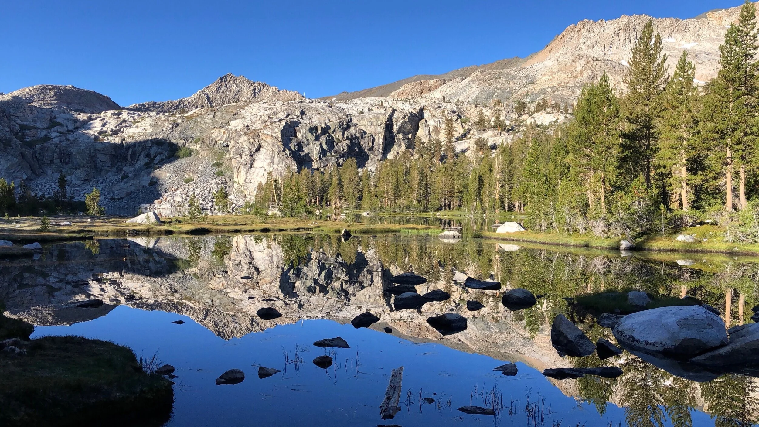

I couldn’t wait to leave our forested campsite for the nearby meadow and bask in the morning sun’s warmth. We gingerly trotted to the meadow. The cold stung my skin, but the scenery more than made up for it. When we entered the meadow, the ground was peppered with frost and the lake stood statue still, reflecting mirror images of the adjoining mountains and lines of trees. I found refuge on a sun-splashed granite boulder. There, Reko and I enjoyed our breakfast (Justin’s Almond Butter, one huge cookie, and a protein bar). When we were done, the frost on the ground had nearly all melted. We made our way back to our campsite and started packing.
I had initially regretted not hiking farther the previous day to camp at Big Five Lakes. Yet, as we began our journey to Big Five Lakes, I realized we made the right call. Although we had only hiked five miles on day two, they were grueling and felt more like 10 miles (thanks, Black Rock Pass). I don’t think I would have made it to Big Five Lakes in one piece if we attempted it the day before. The stretch between Little and Big Five Lakes is relatively flat with a mix of mellow uphills and downhills. Despite its tamer terrain, a bid for Big Five Lakes would've turned my legs into jelly after taking a beating from climbing 3,000 ft over three miles.


Admiring the views of the Kaweahs during the descent from Big Five Lakes to Lost Canyon
When we arrived at the outskirts of the first lake at Big Five Lakes, we slid off our packs and discreetly hid them near some boulders. Now with our backs freed, we could explore the area with ease. We stuffed our lunch (Spam and Tuna Creations packets) into our pockets, brought our water filter, and took off for a few hours touring several of the lakes. We ate lunch at the third (and largest) lake, enthralled by the splendid setting. Sadly, we didn’t have enough time to visit all five of the Big Five Lakes.
I personally prefer Big Five over Little Five Lakes because the landscape is so much grander (I mean, it is in the name: Big Five Lakes). Though, it was much busier than Little Five Lakes, so if you’re seeking solitude, the latter might be the superior option. Either way, both are still exceptional eye candy. (Note: both lakes have bear lockers.)
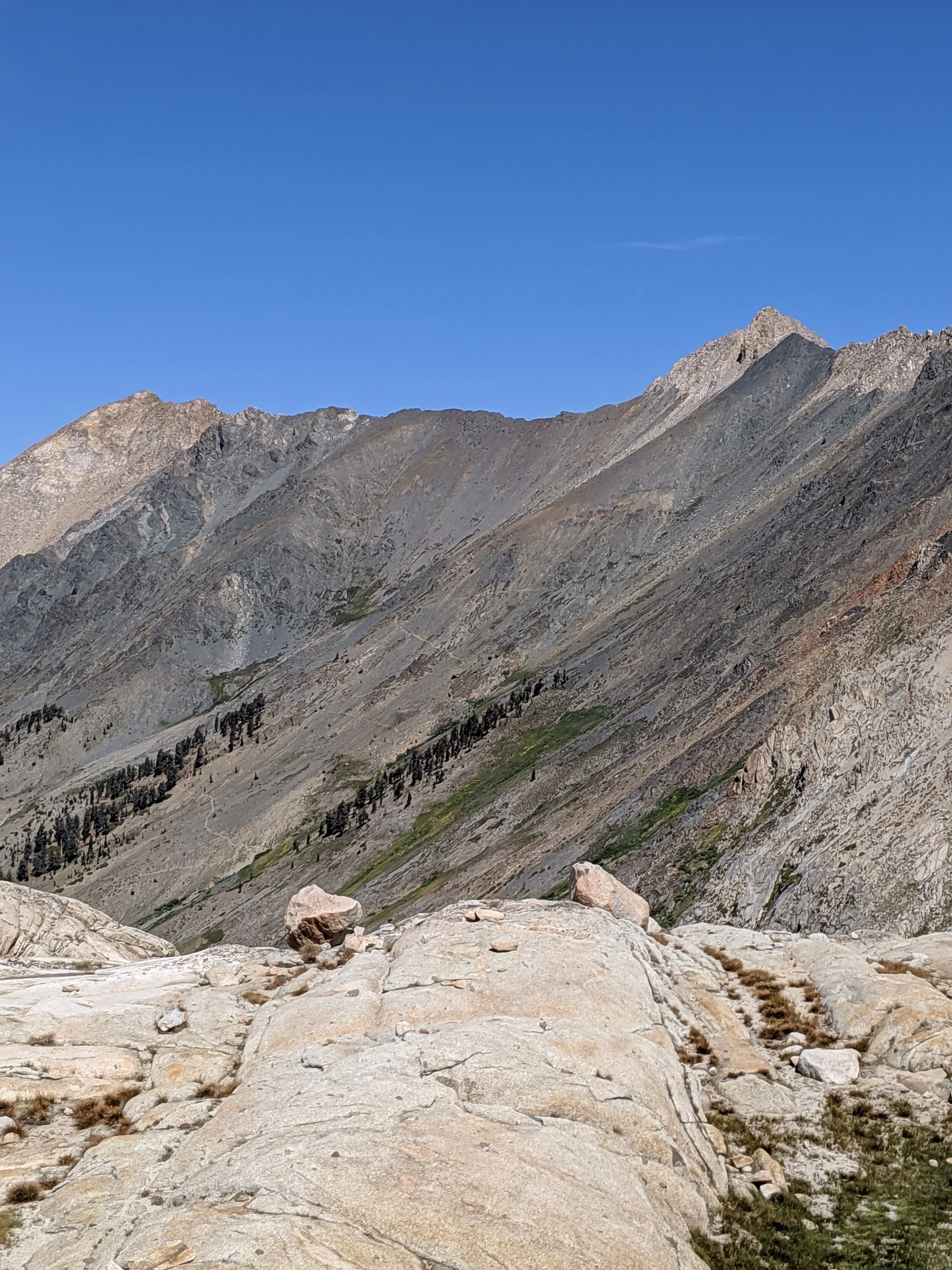
Around 1:30, we returned to retrieve our backpacks and began the next segment to Lost Canyon. The trail starts with a steady uphill climb that offers exquisite views of the Kaweahs—jagged granite peaks laced with remnants of winter snow. The trail then descends into Lost Canyon with a series of switchbacks. At the end of each switchback, we stopped to admire the mountain ranges and peaks. They soon disappeared as we dropped lower and lower until we reached the forest floor, and our views of the craggy mountains were replaced with soaring trees.
We then reached a junction where we turned right for Lost Canyon. The forested trail starts to gently gain elevation. Eventually, the tree cover recedes revealing an idyllic alpine meadow that stretches up canyon towards the Great Western Divide and Sawtooth Peak. This section of Lost Canyon is ridiculously photogenic and quintessential Eastern Sierra: A lush carpet of grass and flowering plants with a meandering creek snaking between sky-high granite monoliths on either side.
We mistakenly thought there were campsites once we ascended the treeline. It was hard to fathom since the surroundings were rocky and dense with vegetation. Reko even ventured off trail a bit (maneuvering over the rocks, not vegetation) to hunt for a campsite. I stayed behind on the trail. He gave me a scare because he didn’t return in 20 minutes as he had promised. Turns out, he went farther than he initially planned (and he tripped and fell).
Exhausted, hungry, and still in search of camp, we marched on, fueled by the dazzling meadow views that continued to unfold before us. After two miles from the junction, we found established campsites at the edge of the meadow. Yay!
Lost Canyon campsite
This evening offered one of my most memorable sunsets in the backcountry. The sky turned into a glowing cocktail of blues, oranges, pinks, and purples. Truly mesmerizing. The evening was chillier than prior nights so we crawled into our tents after polishing off our dinners. We had one more day left in this magical alpine paradise.
That night, I experienced the most frightening night in the backcountry. I’m not sure what time it was but at some point during the middle of the night, I was woken up by noise outside our tent. (I’m a very light sleeper.) It was the sound of footsteps and leaves/dirt rustling under the weight of something…or someone. The rhythm of the steps resembled a person walking. I froze in terror. I strained my ears to listen. I told myself it was a deer but it really sounded like a person walking. Maybe it was a backcountry ranger? But why would he/she be out so late and touring our campsite? The crunching of leaves/debris continued for a few minutes. The moon was bright so I could actually see the shadows of the neighboring trees splashed around our tent’s rainfly. I couldn’t see any objects moving but I couldn’t deny there was commotion outside.
I was on the verge of hyperventilating; my heart raced a million miles per hour and I could feel my body tense up and my temperature rising. All the while, Reko was sleeping like a log. To this day, I don’t know why I didn’t wake him up. Perhaps I was afraid of creating a stir inside the tent and scaring the creature outside (or worse, drawing attention to us). After what felt like an eternity (maybe 10-15 minutes) the noise disappeared, and I assume so did the party responsible for making it. Along with my sleep.
Day 4: Lost Canyon to Sawtooth Trailhead via Sawtooth Pass
The morning Sun lit up our tent, acting as a natural alarm clock. I woke up and recounted the eerie experience to Reko. When we unzipped our tent and stepped outside to investigate, our packs and gear were in the same conditions that we had left them the night before—except for some frost that dusted the top of our backpacks. We didn’t find any prints or obvious disturbances on the ground. Perhaps it truly was just a deer.
This was the coldest morning I had experienced in the backcountry. I’ve never woken up to frost on our backpacks. We quickly ate our breakfast bars and packed up. It was a bittersweet morning as we had reached the end of our adventure. Moreover, Lost Canyon was my favorite part of our trip thus far. I stopped frequently to stare at the sprawling grassy meadow and the massive granite walls that flanked us. Sawtooth Peak loomed in the distance, jutting into the jewel-blue sky like the tip of a carving knife. The hike through Lost Canyon was as easy on our legs as it was on our eyes: a small, gradual incline that allowed us to soak in the sweeping views.


At the end of the meadowy canyon, the trail turns into a series of switchbacks that lead up to Columbine Lake. The ascent was nowhere near as grueling as Black Rock Pass. Plus, our packs were much lighter at this point. I didn’t know what to expect at Columbine Lake—that worked in my favor. When we crested the ridge, we were in awe.
Sawtooth Peak reflected in Columbine Lake
Columbine Lake is a gem, nestled directly under Sawtooth Peak, which, at the time, still carried some patches of snow. The image of the surrounding granite cliffs was stamped onto the lake’s deep blue waters. This lake is easily one of my favorites. We spent an hour exploring the shores, snapping photos, and catching fish (with our eyes!). The lake is modest in size with a few established campsites around its shores. However, when we picked up our permits, the park ranger informed us that camping is discouraged at Columbine Lake because the land is fragile and overused. Please adhere to this recommendation.
This lake stole my heart. It’s difficult to find another more stunning alpine lake in the Sierra, and equally as difficult to describe the tranquility and grandeur one experiences in its presence. I wish we had more time to enjoy Columbine Lake. I wasn’t anticipating to be swept off my feet, but this little gem left me yearning for more.


Sadly, it came time to continue on our hike. We reluctantly turned our backs to the lake and headed towards the northern shore to begin our trek up to Sawtooth Pass. The trail turns into a faint sandy path that’s almost hidden among the rocky outcrop. Navigation was tricky but as long as you follow the cairns—and there were plenty—you will eventually reach the summit of Sawtooth Pass. And oh my, the summit wowed in every direction: Columbine Lake, Black Rock Pass, and the forested Mineral King Valley below.


It was an uninterrupted visual recap of our entire trip from 11,600 ft above. We peeked down into Mineral King Valley, where our journey began. We gawked at the zig-zagging tattoo that was Black Rock Pass. We savored one last glimpse of Columbine Lake. It was a beautiful apex.
Then, it came time to hike down the west side of Sawtooth Pass and to the end of our journey. This is less of a hike and more like gravel-skiing. The west side of Sawtooth Pass is essentially a steep scree, with no official trail. Route finding is rendered to choose-your-own-adventure down to your next destination: Monarch Lakes. The park ranger told us, that as tempting as it is to veer left directly towards the lake, it’s actually easier and safer to stay to the right and head in the direction of a cluster of 6-7 trees. So, down we went on the sandy slope. Thank goodness for trekking poles. If you’re considering doing the Mineral King Loop in the counterclockwise direction, you’d have to climb UP this rocky side of Sawtooth Pass early on in your trip (with full packs). Personally, no thanks. You can make out the two brave souls in the photo on the right who attempted this toilsome endeavor.
We managed to safely traverse the loose gravel and make our way to Monarch Lakes. There were scores of campers, which contrasted with the solitude we experienced most of our trek. We refilled our water bladders and cruised on down the last leg of our excursion—4.2 miles to the finish line. The remainder of the hike was on a well maintained trail and it was uneventful, other than a cute encounter with a mama quail and her chicks. A mile out from the trailhead, were switchbacks that seemed never-ending. At last, we reached our car and rejoiced that we survived the hardest backpacking trip of our lives, and successfully wrapped up the 2019 backpacking season.
After getting ridiculously spoiled by the gorgeous Thousand Island Lake just a month prior, Mineral King at first left me unimpressed. Although, with time (like one year later), I’ve come to appreciate Mineral King a lot more. The sights and beauty grow on you. Lost Canyon and Columbine Lakes are the standouts. Plus, the near perfect solitude is rare in these parts of the Sierra and might just warrant a second outing.